| Eco Companion Australasia |
| Dataset description |
Eco Companion environmental resources catalogue and online document management service
Dataset description contents:
Note: this dataset description is metadata (data
about data) which describes the actual dataset in accordance with the ANZLIC
(Australia New Zealand Land Information Council) Core Metadata
Guidelines
v2
ANZLIC unique identifier: ANZCW1003100007
Title: Eco Companion environmental resources catalogue and online document management service
Custodian: IndexGeo Pty Ltd
Jurisdiction: Australia
Abstract:
Eco Companion Australasia is an environmental resources catalogue and online document management service.
The catalogue contains collections of concise descriptive documents
comprising geospatial dataset descriptions, business outlines, and
contact details.
These documents are managed by Eco
Companion members using online document management facilities and
contribute to the searchable catalogue.
Online facilities for document management means that managers can
concentrate on describing the content of their documents, rather than
fussing about with installing and managing the software. Eco
Companion facilites take care of all of the technical stuff.
Batch processing facilities are available to gather a collection of
geospatial metadata from a remote Internet site, validate the XML
documents and produce HTML and text presentation documents.
The Internet service is developed and managed by IndexGeo Pty Ltd.
ANZLIC search words:
Spatial domain:
- Geographic extent name:
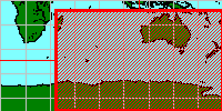
- Australia including external territories - AUSAAT
- Geographic extent name:
- New Zealand Mainland (NZ)
Geographic bounding box:
Outer bounding rectangle as Latitude/Longitude coordinates based on the WGS84
datum (expressed as both Degrees Minutes Seconds and as decimal Degrees):
- North bounding latitude: 9 00 00.0 S (-9)
- South bounding latitude: 90 00 00.0 S (-90)
- East bounding longitude: 180 00 00.0 E (180)
- West bounding longitude: 45 00 00.0 E (45)

- Beginning date: 16 October 1997 (1997-10-16)
- Ending date: Current
- Progress: In Progress
- Maintenance and update frequency: Continual
- Stored data format:
- Digital HTML, plain text, SGML, XML
- Available format type:
- Digital HTML, plain text, XML
- Access constraints:
- No restrictions. Copyright and responsibility rests with the author of the document.
Lineage:
All documents are continuously maintained by
Eco Companion members using online
document management facilities. The set of
published documents that are visible through
browse and search are always the current set.
Positional accuracy:
Automated document management facilities ensure
that the dataset descriptions are referenced by
legitimate geographic coordinates.
Attribute accuracy:
Automated document management facilities ensure that all documents are described using only legitimate values. The allowable values for various metadata elements are compared against the relevant authority lists.
Eco Companion editors oversee the document collections to ensure consistency and reliability.
Logical consistency:
When Eco Companion authors edit their documents, the automated facilities will compare the document against the relevant SGML/XML Document Type Definition ( DTD) to ensure that the document structure is sound. Various content checks are also automatically carried out.
The collection of geospatial dataset descriptions is structurally
validated against the ANZMETA SGML/XML DTD for geospatial metadata
and the content is automatically checked against the ANZLIC Metadata
Guidelines.
The hypertext links in all Eco Companion documents are
regularly and automatically checked to ensure that there are never
any broken URLs.
Completeness:
The catalogue has ongoing contributions by Eco Companion members.
- Contact organisation: IndexGeo Pty Ltd
- Contact position: Editors
- Postal address: 160 Cowper Street
- Locality: Goulburn
- State: NSW
- Country: Australia
- Postcode: 2580
- Telephone: 0419 259 705
- Facsimile:
- Electronic mail address: info@indexgeo.com.au
- Metadata date: 21 June 2001 (2001-06-21)
- Metadata reference: http://www.indexgeo.com.au/ec/pub/crossley/dataset/eco-companion.html
Online documentation
This dataset description complies with
ANZLIC Core Metadata Guidelines v2
and XML DTD ANZMETA 1.3 (metadata validation date: 2001-06-21)
