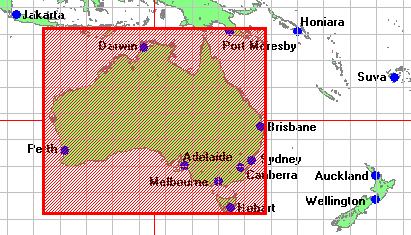
Note: this dataset description is metadata (data about data) which describes the actual dataset in accordance with the ANZLIC (Australia New Zealand Land Information Council) Core Metadata Guidelines Version 2 (February 2001)
ANZLIC unique identifier: ANZCW1003100008
Title: Location of Australian capital cities
Custodian: IndexGeo Pty Ltd
Jurisdiction: Australia
The geographic coordinates of each capital city of Australia are listed.
This dataset is a comma-separated values CSV file with one entry per line (longitude, latitude, city name) ... capital.csv
There is also an example PNG image portraying the location of the capital cities with symbols and labels. The image can be used as a map overlay ... capital.png
This dataset is also available as a layer in the Web Mapping Service (WMS).
- BOUNDARIES Administrative Resources
- BOUNDARIES Administrative Maps
- Geographic extent name:
- Australia excluding external territories - AUS
Note: The format for each Geographic extent name is: Name - Identifier - Category - Jurisdiction (as appropriate)
Geographic bounding box:
The bounding box encloses the maximum extents of the dataset. There may be voids or gaps within the bounding box, depending on the defined coverage of the dataset. Outer bounding rectangle as Latitude/Longitude coordinates based on the WGS84 datum (expressed as both Degrees Minutes Seconds and as decimal Degrees):
- North bounding latitude: 9 00 00.0 S (-9)
- South bounding latitude: 44 00 00.0 S (-44)
- East bounding longitude: 154 00 00.0 E (154)
- West bounding longitude: 112 00 00.0 E (112)

Lineage:
Geographic coordinates were obtained from the AUSLIG Australian Place Names lookup service (which interrogates the "Gazetteer of Australia" dataset).
The simple listing was created with a text editor by copying and pasting the values that were returned from the Internet lookup service.
Positional accuracy:
Longitude and latitude are rounded to 2 decimal places. The precision supplied by the AUSLIG public Internet service is 3 decimal places.
Attribute accuracy:
The CSV file has 3 fields: city name, longitude, latitude. These parameters are validated by importing the CSV file with the mapping software Manifold and the map image is produced. The mapped locations and label names are visually checked with a graticule overlay.
To minimise potential human errors, the process was separately repeated. The resultant two data files were compared for differences using the UNIX utility "diff".
Logical consistency:
The CSV file has a consistent, well-structured format (explained above). Each entry is guaranteed to conform to that format.
Completeness:
The dataset is complete. Every Australian capital city is listed (i.e. Adelaide, Brisbane, Canberra, Darwin, Hobart, Melbourne, Perth, Sydney).
The data file and the map image are available from http://www.indexgeo.com.au/data/capital/ together with supporting documentation.
This dataset description complies with ANZLIC Core Metadata Guidelines Version 2 (February 2001) and XML DTD ANZMETA 1.3 (metadata validation date: 2004-05-13)
| Eco Companion Australasia |
| Dataset description |
| Eco Companion home | browse | search | new |